


At Lamma, the agonomy and farm management software specialist, Hutchinsons, will introduce the PowerZone functionality to its Omnia system.
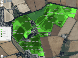
The new map layer identifies field zones of differing yield potential, using up to 15 years of historical satellite biomass data, revealing the areas that consistently perform well, as well as those which do not.
The company states that this will aid growers in making informed decisions about variable rate applications of seed, fertiliser and crop protection products.
“The PowerZone map essentially highlights which parts of a field consistently perform well and which parts perform less well (lower potential) over the years,” explains Lewis McKerrow, head of digital agronomy with Hutchinsons.
“It’s comparable to soil zone maps in the way it identifies underlying field variation and allows users to define management zones. PowerZone uses long-term biomass data to build a picture of field performance potential and creates a single, easy-to-use map layer within Omnia.”
It’s facilitated through the xarvio Field Manager platform from BASF and has already been used by xarvio customers across Europe. The integration into Omnia will mark the first time it has been available to UK customers.
 Omnia will be the only UK platform to offer PowerZone, which will be available to those with Business Manager accounts at no additional cost.